한국항공우주연구원
Mobile GnbKASS
Satellite Navigation System More accurately
Satellite Navigation
Core infrastructure for the Fourth Industrial Revolution era of the satellite navigation system and autonomous driving
The satellite navigation system that we commonly know as GPS (Global Positioning System) is a system that provides positioning, navigation, and time (PNT) information from satellites. It is widely used for military purposes, requiring a very small built-in receiver in smartphones to use the satellite data regardless of where the user is. Moreover, it can process signals in real time even when the user is on the move. Its use is limitless, such as guiding vehicles and ships and serving as essential infrastructure for people’s daily living for emergency rescue and disaster prediction. Korea relies on US commercial GPS signals with built-in position error of about 10 meters. Therefore, they cannot be used directly for aviation, which requires precision location information, or industrial infrastructures such as autonomous driving due to poor GPS signal quality in Korea with many urban structures and mountainous terrain. Moreover, while everyone can currently use GPS signals, all systems that depend on GPS signals will be paralyzed if GPS is terminated due to signal failure or conflict of interest between countries. A stable, high-precision, high-reliability satellite navigation system is crucial for the 4th Industrial Revolution and future national growth. It should be implemented and operated at the national level. Countries like the United States, Russia, Europe, China, Japan, and India are already operating a satellite navigation system that can provide centimeter-level services. Korea had remained a mere user country of the satellite navigation system until the early 2000s. Recognizing the need for a systematic response to satellite navigation, the Korean government finalized the Master Plan for the Comprehensive Development of the Satellite Navigation System in December 2005, which includes the plan to develop a Korean regional satellite navigation system in the Mid- to Long-term Plan for Space Development announced in December 2013. KARI kicked off the project to develop the Korea Augmentation Satellite (KASS), the precision GPS location augmentation system, sponsored by the Ministry of Land, Infrastructure, and Transport. The project develops the satellite-based augmentation system (SBAS), one of the technologies to reduce the GPS location error to less than 3 meters, to suit Korea’s terrain and environment. Developing the KASS is the first step for the satellite navigation system, and KARI is investing in securing base technologies and training specialized personnel. Moreover, KARI is preparing to kick off the project to develop the Korean Positioning System (KPS) to implement Korea’s independent satellite navigation system, which is considered the core infrastructure for the 4th Industrial Revolution such as autonomous driving.KASS
Improvement of GPS location error to less than 3 meters
The current GPS location error is about 10 meters, limiting its use in fields that require precision location information such as aircraft. To address such limitations, Europe (EGNOS), Unites States (WAAS), India (GAGAN), and Japan (MSAS) are operating the Satellite Based Augmentation System (SBAS), which improves the accuracy and reliability of GPS signals. SBAS improves the GPS location error to less than 3 meters and provides the information needed to confirm its reliability throughout the country through geostationary orbit satellites. Since the data is very reliable with an error probability of less than 1/5 million (error occurring once every 18 years), the International Civil Aviation Organization (ICAO) aims to increase its use in flight airspace to support the continuously growing air traffic volume. The organization has designated SBAS as the international standard, recommending that countries operate and use the service to increase satellite navigation accuracy and reliability. Korea is developing and implementing the Korea Augmentation Satellite System (KASS), an independent satellite-based augmented navigation system, since 2014 as a project by the Ministry of Land, Infrastructure, and Transport. KASS is being developed under SBAS international standards to meet Korea’s accuracy and reliability requirements and suit the country's topography and environment. KASS enables Korea to use satellite-based technology as well instead of depending on ground-based navigation safety facilities. The goal of KASS, which is the world’s 7th development of SBAS, is to provide air navigation information and various kinds of location-based information close to people’s lives. Its development started in October 2014 with KARI as the project manager, and the aviation service is scheduled to start in 2023 after the system design, production, and performance certification.Use for aircraft safety and emergency rescue
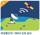
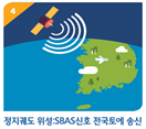
KASS receives GPS signals from domestic ground reference stations (7 locations), extracts navigation messages, and transmits them to the central processing stations (2 locations). Subsequently, the central processing station corrects the GPS error information and generates correction and integrity information necessary to notify whether the GPS signal is normal. It then transmits the data to the satellite communication station, which in turn generates SBAS signals (SBAS messages) and transmits them to geostationary orbit satellites. The information is finally broadcast by the geostationary orbit satellites throughout the country. A receiver installed in an aircraft or a vehicle can receive GPS signals and SBAS signals at the same time to check their exact location. If there is an error in the signal, the automatic SBAS alarm system provides an alarm notifying the prevention of use within 10 seconds so that the users can have confidence with the data.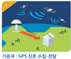 |
 |
 |
 |
| ① To receive GPS location information | ② Error value correction and integrity data for satellites | ③ Correction of signal satellite service | |
| Reference Station (7 Locations) | Central Processing/Integration Station (2 Locations) | Satellite Communication Station (2 Locations) | SBAS Satellite (Leased) |
| GPS signal reception SBAS signal reception | GPS error calculation, SBAS data generation and control | SBAS signal transmission to satellites | Delivery of SBAS signals throughout the country |
- GoalTo use satellite navigation for aircraft safely by reducing the GPS error to less than 3 meters
- Schedule2014 KARI selected as the project managing agency / 2023 To begin aircraft services