한국항공우주연구원
Mobile GnbNews Release
Footage of Japanes epicenters of earthquakes and tsunami captured by Arirang 2
- Department Administrator
- Registration Date 2011-03-15
- Hits 19391
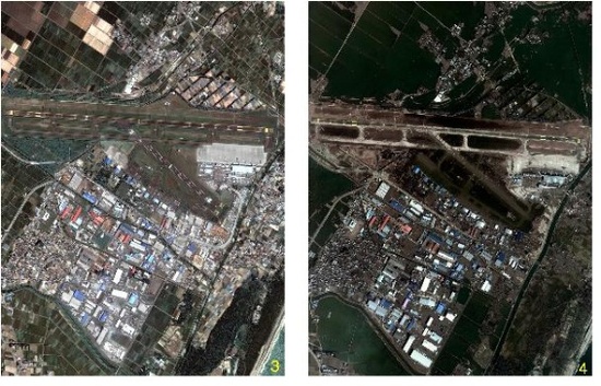
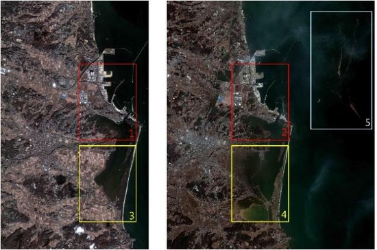
On March 11, 2011, an earthquake of magnitude 9.0 hit 179 km off the east coast of Sendai, Honshu, Japan. It has caused serious breakdowns of facilities, massive damage to human lives and properties across the northeastern parts of Japan which was exacerbated by series of tsunami and aftershocks.
Regarding the earthquakes and tsunami in Japan, the Korean Ministry of Education, Science and Technology (Minister: Lee Ju-ho) and the Korea Aerospace Research Institute (Acting President: Lim Cheol-ho) recently provided the International Charter with satellite footages of epicenters captured by Arirang 2 on March 14, 2011 as part of the support for the Charter to implement effective countermeasures against additional damage or disruption and to analyze damage in the wake of disasters.
These footages display the pre and post scenes of Japanese earthquakes and tsunami captured by Arirang 2 during its mission at the request of the International Charter, thereby giving quick glimpses of the catastrophic disaster scenes across Sendai and Soma in the northeastern part of Japan.
The International Charter is an international cooperation organization voluntarily formed by space development institutes in 13 nations that are equipped with satellite systems including European Space Agency (ESA), the Centre National dEtudes Spatiales (CNES), the National Oceanic and Atmospheric Administration of the U.S. (NOAA), the Japan Aerospace Exploration Agency (JAXA), and the China National Space Administration (CNSA). In the event of natural or other disasters, it provides free images taken by satellites of member states as part of the humanitarian assistance for nations across the globe.
After the Japanese earthquake, continuous image-taking is being currently undertaken through the satellite systems of signatories of the International Charter such as the U.S., Germany, and France, thereby allowing the acquisition and delivery of over 300 images.
The Korean Ministry of Education, Science and Technology announced that it would establish humanitarian support system based upon the Arirang satellites within the international community through cooperation with the International Charter. It would also interact more with worlds leading satellite development institutes while expanding the utilization and support of Korean satellite data for future detection and damage analysis of global disasters.
Footage of Japanes epicenters of earthquakes and tsunami captured by Arirang 2
- Sendai
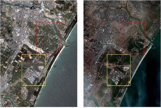
Jun 17, 2008 Mar 14, 2011
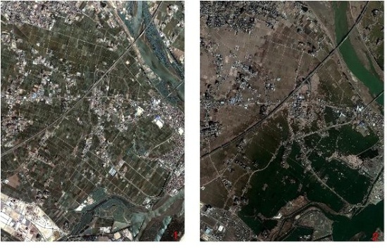
- Soma
Nov 10, 2010 Mar 14, 2011