한국항공우주연구원
Mobile GnbNews Release
Scene of Haiti Earthquake Shot by Arirang-2
- Department Administrator
- Registration Date 2010-01-18
- Hits 20371
The Korea Aerospace Research Institute (hereinafter referred to as “KARI”" headed by President Lee Joo-jin) disclosed satellite images of the scenes of the Haiti earthquake as photographed by Arirang-2, a.k.a. KOMPSAT-2, or Korea Multi-Purpose Satellite-2, on January 13 and 16, 2010.
Taken by the satellite before and after the Haiti earthquake during its mission, these images provide a complete view of the tragic disaster.
Arirang-2 is a low-orbit, applications satellite capable of producing 1-m resolution imagery of the globe and, since its launch on July 28 2006, has been performing its mission of observing the globe and the Korean peninsula as of today, well past the expiry of the official service period on July 28, 2009.
Since taking its first batch of shots in August 2006 for validation and calibration purposes, KOMPSAT-2 has conducted a total of 24,185 imagery sessions up until January 17, 2010, producing a total of 1,237,262 images (15km × 15km).
KARI announced that it would provide these Haiti images taken by Arirang-2 to the International Charter on Space and Major Disasters, an international collaborative organization organized to provide satellite images when natural or man-made disasters occur anywhere in the world, to allow recovery from and identification of the magnitude of damage, and that it would seek to become a full member of this organization in 2010 so that the space technologies of Korea may be more utilized for international collaboration and humanitarian purposes.
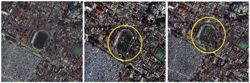
Taken in April 2009 before the Haiti earthquake and on January 13 and 16, 2010 after the quake, one of these Arirang-2 images shows a number of residents who have taken refuge at a soccer stadium after the disaster.
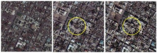
This image shows that Port-au-Prince Cathedral is destroyed after the earthquake.