한국항공우주연구원
Mobile GnbNews Release
Arirang 2 signed a $22m deal last year
- Department Administrator
- Registration Date 2009-01-20
- Hits 19686
Recognized for the quality of its satellite images by ESA
The Ministry of Education, Science and Technology announced that it has signed contracts with three overseas institutions, one of which is the European Space Agency (ESA). Korea’s multipurpose satellite Arirang 2 will supply satellite images over the next three years under these contracts, which total $22 million.
Exporting Korea’s satellite images to advanced space development agencies like ESA is extremely significant because it shows that the nation’s space technology and the quality of its satellite images have gained recognition overseas.
The Korea Aerospace Research Institute (KARI), headed by Lee Joo-jin, receives satellite images taken by Arirang 2 ten times a day via the ground station in the North Pole operated by Kongsberg Satellite Services in Svalbard, Norway. KARI then transmits the images to ESA. The Institute also allows sales promotion agencies to sell the images to other regions for commercial use.
KARI is operating two sales promotion agencies, Korea Aerospace Industries Ltd. and Spot Image, a French satellite imagery provider. The purpose is to actively market the images captured by the multipurpose satellite throughout the domestic and international markets. KARI is also directly in charge of satellite image distribution for public purposes domestically.
In 2008, KARI established a basis for utilizing satellite imagery by providing a total of 613 images to 69 different agencies, such as local governments, universities, and research institutes. The images were used to monitor the situation of the site selected for the Yeosu Expo, to provide a map service based on satellite photos for Daegu City, and to be displayed in the special exhibition entitled ‘Goguryeo and Balhae seen from the sky’ at the Seoul National University Museum.
Recently, KARI has begun to provide images taken by the Arirang 2 satellite to an online map service accessible to everyone. KARI plans to expand the service, due to the ease of updating images on a regular basis.
The government also has plans to provide training programs for experts, carry out promotional activities, and launch pilot projects for the widespread use of satellite images in three dimensional geographic information systems, for natural disaster prevention, and for environmental pollution prevention.
Launched in July 2006, Arirang 2 orbits at a height of 685 km, circling the earth 14 times a day. It takes one meter resolution images in black and while and four meter resolution images in color.
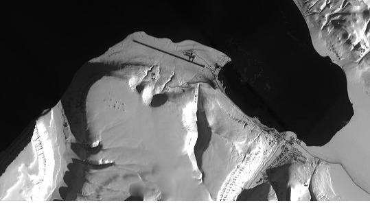
< Satellite image of the area surrounding the ground station in Svalbard, Norway>