한국항공우주연구원
Mobile GnbNews Release
KARI signs an MOU with Chungnam province
- Department Administrator
- Registration Date 2008-09-17
- Hits 9617
To pursue the utilization of satellite information in the public sector and to develop G2C services
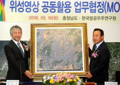
On September 16th, the Korea Aerospace Research Institute signed a Memorandum of Understanding with the Province of Chungcheongnam-do at the Chungnam Provincial Government office to support the utilization of satellite information in the public sector.
President Paik Hong-yul of KARI, Governor Lee Wan-koo of Chungcheongnam-do Province, and Geographic Information System (GIS) related personnel were present at the MOU signing ceremony. The two parties to the MOU agreed to cooperate jointly in the development of related industries, and to facilitate the use of satellite imagery in the public sector.
The main contents of the MOU include ▲concerted efforts for cooperation and the sharing and utilization of research information, technology, human resources, and facilities in the implementation of local administrative G2C services through satellite information applications ▲cooperation and sharing of the technology, facilities, equipment and materials necessary to develop three-dimensional GIS, and the use of earth-observation satellite information. ▲ sharing of the two parties’ information, providing education programs, and cooperating through workshops to expand the use of satellite information for public purposes. ▲ the setting up of a cooperative committee where experts from the two parties can participate when joint projects are being conducted.
There have been difficulties, such as high costs, in putting together the necessary materials for the GIS construction project, as aerial photos and satellite imagery are currently only available from overseas sources. But since 2008, high-resolution satellite images have been taken and distributed domestically, contributing much to the development of the satellite imagery industry.
In particular, this MOU has enabled KARI to lay the foundation for the utilization of satellite information in the public sector. The Chungcheongnam-do component of this project is intended to facilitate GIS business in the region, while making low-cost, rapid data replacement possible in its plan to integrate and set-up records of land registration, topographical maps, and satellite imagery. Taking these expected desirable conditions into account, it is mutually beneficial for the two parties to cooperate and contribute to each others progress.
President Paik Hong-yul of KARI said “Korea is able to process satellite photos on its own and provide them to the domestic market. It’s meaningful that we build a cooperative relationship with Chungcheongnam-do in the development and expansion of the utilization of satellite imagery. We’ll continually endeavor to facilitate cooperation in the distribution of satellite imagery technology and other areas.”
Meanwhile, KARI has also signed a similar agreement with Daejeon Metropolitan City on August 18th, and is engaged in negotiations with other local governments for additional agreements.